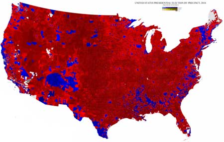
What you are looking at there is TRUMP COUNTRY! Run away! Run Away! To the far far corners of the nation! I suppose this settles the issue that the divide is more rural/urban than anything else. But there are a few other things that can be garnered from this map.
This map was created by Washington University graduate student Ryne Rhola who took the time to form it from individual precincts. Ryne Rhola is a cartographer not a political student which we must keep in mind.
The Ultimate 2016 Presidential Election Map
There isn’t even a blue dot of any kind in Nebraska, Kansas and Oklahoma. You know, the top the tourist attractions of America. The deep South is bluer than the Midwest, but at least we can see where most of the black people live there. And of course where most Hispanics live. But even the so called blue states are almost completely red.
So what is it about rural Americans?
Could it be chemicals in Hardee and Carl Jr french fries?
Could it be the areas are all white?
Could it be the white gravy?
Could it be too much manure in the air?
Could it be too much beer, meth and heroin?
Could it be that Jesus is a right-wing lunatic?
Could it be nothing to do but sit home and watch Fox News?
Could it be there is nothing to listen to but Rush Limbaugh?
Could it be a social life revolving around Walmart parking lots?
Could it be more guns than brains?
Could it be hatred of anyone perceived smarter than they are?
Could it be lack of education?
Could it be they have nothing to do and no place to go?
Or, could it be that anyone with a lick of sense moved away as fast as possible?
One thing is sure, rural people live inside a impenetrable parochial bubble of ignorance, propaganda, resentment and whiteness while urban people live in an open multicultural and multi-ethnic melting pot with all kinds of people doing all kinds of things with more places to go and things to do than they can manage in a lifetime.